

Lake Dunstan Trail

Lake Dunstan Trail Map & Sections
The Lake Dunstan Cycling & Walking Trail can be accessed from Cromwell or Clyde. Along the way you will marvel at the man-made landscapes, rich Maori and early pioneer history, and vineyards as you travel along the Lake Dunstan Trail.
From raging rivers, goldminers Hartley and Reilly, the Cairnmuir Slide, a unique climate and much more – the area has many of its own stories to tell which you will learn about along the way.
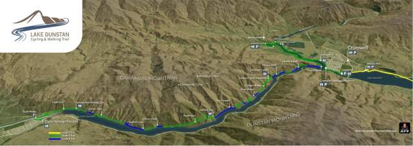
Lake Dunstan Trail Sections
-
Smiths Way to Cromwell Heritage Precinct - 16km, Grade 1
This section of the Lake Dunstan Trail is a popular day ride or walk to / from Cromwell. It wends its way alongside Lake Dunstan from Smiths Way via Pisa Moorings to Cromwell.
There are many places to rest a while beside the lake, with swimming, boating and other water sports all popular along most of its distance. At Cromwell Heritage Precinct be sure to park up and explore the boutique galleries, retail stores, restaurants and cafes.
This is an ideal section of trail for families or beginners to enjoy. Check out this great family friendly ride itinerary.
-
Cromwell Heritage Precinct to Bannockburn Inlet - 7km, Grade 2
Following the Kawarau arm of Lake Dunstan to the Bannockburn bridge, you will have amazing vistas across the lake to Bannockburn vineyards and the next section of trail which loops back round on the opposite side. Along the way there are sections where the land has been reshaped in the search for gold and then again when the lake was formed.
After crossing the Bannockburn bridge loop around to Bannockburn Inlet where there is a toilet, and parking available.
It is possible to return to Cromwell on a trail alongside Bannockburn Road - making for a wonderful short and family friendly day ride. Click here for a more details of a great family ride on the Lake Dunstan Trail.
-
Bannockburn Inlet to Cairnmuir Gully - 11.3km. Grade 2-3
The trail loops around the Bannockburn Inlet which is a popular picnic area with a designated swimming area. As it continues toward Cornish Point it passes by vineyards and olive groves - with views back across to Cromwell and the Heritage Precinct.
This section includes the first of the bluff bridges, and you will cycle at the base of the stonework faces of the Cairnmuir slide, a unique feature high on the slopes above the lake. It was designed to protect the river from a major land slide, which could overwhelm the Clyde Dam, a short distance downstream.
As you go, look out for the drainage tunnels dotted along the length of the gorge. There are 13 tunnels (total 18.5km of tunnels) drilled into the hillsides of the gorge in the mid 1990’s. These tunnels are also used to mitigate against landslips into the Clutha River.
-
Cairnmuir Gully to Halfway Hut - 8.4km, Grade 2 - 3
This section requires the most attention and skills as there are narrow sections and more gradient.
The aptly named Cairnmuir Ladder, may look daunting but the switchbacks have been designed to a maximum of 6 degree gradient with a 3m minimum radius. This is section contains the highest point of the trail, rewarded with magnificent views which also means exposure to the weather.
The Hugo suspension bridge is in the middle of this section with a walkable steep land option for those uncomfortable on the bridge.
Toilets are at either end of this section at Cairnmuir Gully & Halfway Hut
-
Halfway Hut to Dunstan Arm Rowing Club - 10.7km, Grade 2-3
Close to Halfway Hut you will find a short switch back section with tight corners and a good climb / descent. There are plenty of picnic spots to stop at and enjoy the lakeside.
A dominant feature at the Clyde end of the trail is New Zealand’s third largest hydro-dam, the Clyde Dam. This was one of the ‘’Think Big” projects driven by the Muldoon led Government to diversify the economy and drive growth. Started construction 1977. The first power was generated in 1992.
-
Dunstan Arm Rowing Club to Clyde Heritage Precinct - 3.5km. Grade 1
This section follows the sealed road in places, and shares the Clyde road bridge before climbing up towards the Clyde Heritage Precinct.

Carparking & Access
Carparking is available at:
- Smiths Way
- McNulty Inlet
- Lowburn
- Pisa Moorings
- Alpha St Reserve
- Cromwell Heritage Precinct
- Butchers Drive
- Bannockburn Bridge (Pearson Rd)
- Bannockburn Inlet
- Dunstan Arm Rowing Club
- Clyde Heritage Precinct
Please use the above parking locations and park considerately; do not block access to any driveway, boat ramp or trail access point.